CBSE Guess > Papers > Question Papers > Class X > 2009 > Social Science > Social Science
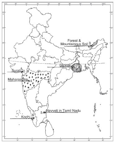
the following information and write their correct names on the lines marked in the map: 6×1=6
(1) Main centre of overseas trade
(2) A large scale industrial region of India in 1931
(3) A type of soil
(4) A major Jowar producing State
(5) An area where coal mine is located
(6) A major sea port.

Or
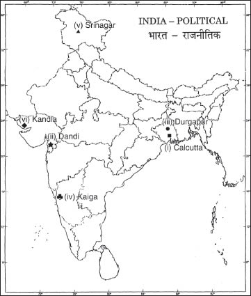
Locate and label the following items with appropriate symbols on the given political outline map of India: 6×1=6
(i) A place where the National Congress session was held in 1920
(ii) A place where Civil Disobedience Movement was launched
(iii) An iron and steel plant in West Bengal
(iv) A nuclear plant in Karnataka
(v) A software technology park in Jammu and Kashmir
(vi) A major sea port in Gujarat.

(29.1) Name the place where Gandhiji organized a Satyagraha to protect against indigo-planters.
(29.2) A place in Gujarat where no tax campaign was launched.
(29.3) Name any one State where forest and mountainous soils are found.
(29.4) Name the port that was developed to decongest Kolkata port.
(29.5) Name the software technology park located in Gujarat.
(29.6) Which Indian State is the largest producer of Bajra? 6×1=6
Ans. (29.1) Champaran
(29.2) Bardoli
(29.3) Jammu and Kashmir or Himachal Pradesh or Uttaranchal
(29.4) Haldia
(29.5) Gandhinagar
(29.6) Rajasthan
| Social Science 2009 Question Papers Class X | |||||||||
| Delhi | Outside Delhi | Compartment Delhi | Outside Delhi | Foreign | |||||
| Set 1 (PDF) | Set 1 (PDF) | Set 1 | Set 1 | Set 1 (PDF) | |||||
| Set 2 | Set 2 | ||||||||
| Set 3 | Set 3 | ||||||||